Well, it’s a little late but here it is – the trip report for Western and Eastern Arthurs traverse. Or not, as it turned out.

The aim of this trip was pretty simple: to go to Tassie with a group of really involved club members to do a hike that is a little more interesting, involved and out there than just Mt Solitary or Acacia Flats in the Blueys. This was bound to be an epic experience that would expand our skills and endurance in longer and more remote hiking. The Southwest National park in Tasmania was chosen as the destination with a traverse of the Arthurs ranges as the objective. This is a stunning and rugged place with high exposed ridgelines and what has been described as Australia’s only real mountain: Federation Peak. It was not to be – but we wouldn’t find that out until much later.
Ben and I were stoked to be given club funding in the form of the Beanie grant, but these feelings were quickly followed by nerves when we thought about the amount of organisation that now had to be done.
Foremost was logistics. How were we going to take a large club trip on a lengthy hike in Tasmania? Charter hiker transport, car hire and hitchhiking were all considered before we landed on the plan of taking 10 people and 2 cars from Sydney down to Tassie. We would then split into 2 groups of 5 and each car would park at an opposite end of the track. The two groups would then walk in opposite directions along the track (and passing in the middle) to each other’s cars. Pretty simple really…
For the walk itself, we decided to allocate 10 days – enough time to allow for a reasonably relaxed pace. But then we would also need to allow for some extra day’s food in case of bad weather – this all adds up to very heavy packs.
The length of the hike, combined with the notoriously bad weather and difficult terrain meant that we would need to consider carefully the people who would come. But would anyone even want to come on this adventure with us? We posted the trip on the website to find out.
As it happened, there was a fair amount of interest. Unfortunately, we were strictly limited by the number of seats in the cars so in the end we picked people who had the experience, enthusiasm and club involvement to make them excellent travelling companions. The original group was Manon, Greta, Brendon, Jenny, Bruno, Leo, Stephen, Lin, Ben and me.
There was a lot of planning that needed to go into this trip. We had several planning nights to get through it all: the food, the gear, who’s cars were going down, who was driving and who was flying, what date would we meet up in Hobart, how long and where would we stay in Hobart before/after the hike, what dates should the ferry be booked for, what should we do with the extra time if we finish the hike early, etc.
In addition, we also had training trips to make sure we were ready for the hike itself, but also to make sure the group worked as a whole – we would be spending more than 10 days together after all. These included trips to the Blueys, Budawangs and Snowies.

The time was finally drawing near to departure in late January. The dehydrator was running 24 hours a day and I was getting antsy in anticipation of the trip. Then came a message in our group chat: the Southwest National park was closed because of fires, hikers had been evacuated by helicopter from Mt Anne – just up the road from where we wanted to go. This threw a bit of a spanner in the works to say the least. But with only a couple of days left before we were due to depart, we figured we’d head down anyway and try our luck. Maybe the park would reopen, maybe it wasn’t that bad.
It was really bad. On the drive to Melbourne a call to National Parks told us that there was no chance of the area reopening in the next week, so that gave us the ferry trip to come up with some new plans.
It wasn’t just the Southwest National park that was closed. Hot and dry conditions combined with thousands of dry lightning strikes had resulted in fires all over the state. There were a large number of road and national park closures, and many local residents lost houses and property. Even just driving South to Hobart on our first day in Tassie we passed through areas where the sunlight was turned into a diffuse red glow and visibility was limited to a few kilometres.
In a hostel in Hobart, with the smell of bushfire in the air, we took stock and decided what to do. We still wanted to see some of the stunning wild places that Tassie has to offer – really it was just a matter of choosing something that was open. Frenchman’s Cap was what we decided on – a 4 day walk in a stunning area. And, importantly, it was a reasonable distance from various fires near the Central Plateau, Rosebery, Lake Gordon and the Southwest Conservation Area.
We had to drive through a lot more smoke on our way to the Frenchman’s Cap trailhead the next day, but we felt better as the air cleared when we got closer. So, around midday we headed off with 4 days food and some vague intentions about side trips.
The trail winds through plains for most of the first day with the sheer face of the Cap visible in the distance. We kept up the pace so that we made it to the Lake Vera hut before dark despite our late start, and that night we decided to attempt White Needle and Sharlands peak on our way to Lake Tahune the next day.
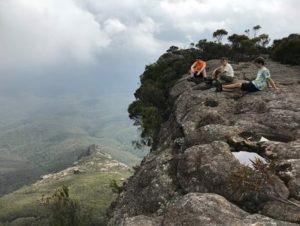
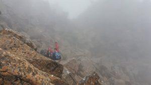
The following morning after a steep ascent to Barron Pass we ditched packs and waded into the scrub at the foot of White needle. There were some not insignificant climbs with some decent exposure on the way up. The views of course were incredible and we stopped pretty frequently for photos.

We descended again with much of the day ahead of us and discussed our next stop for the day: Sharlands Peak. Back at the main track a PWS ranger passed, and we asked for advice on the best route up to the ridgeline. He told us that we needn’t walk a few k’s down the track before doubling back as we had planned; we could just head straight up at a landslide a few hundred meters ahead. We couldn’t miss it, he told us.
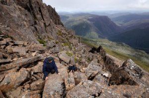
Well we didn’t miss it, but standing at the bottom looking up I had to admit that I had misgivings about how steep it looked further up. But everyone was keen to try and the park ranger had recommended this route, so up the rubble we went.

The landslide was mostly loose rock at a relatively gentle gradient – perhaps for 150m or so. This was loose but easygoing. Right at the top though was the place where all the rock had fallen from; this was much steeper and, as it turned out, just as loose. This top section was perhaps 30m tall.
Bruno led the charge up this last section, with Stephen behind him and Ben and Brendon a little further back. I wasn’t too keen so I hung back and watched (Leo and Manon had – wisely – kept walking to the hut).
I think it’s fair to say that attempting this was a poor decision and could have easily ended badly. Bruno and Stephen got too high to downclimb before realising just how dodgy it was, all the while nocking loose rock down on Ben and Brendon who were hiding behind a boulder below. I was standing a good 50m away and rocks were bouncing past me.
Anyway, we all survived and continued on our way to a beautiful and newly rebuilt hut in a stunning location next to Lake Tahune below Frenchmans Cap. It was so nice that we ended up staying there for two nights. The third day of the walk saw us go to the summit of Frenchmans. The view was stunning, but fires were visible in the distance.
The next day we walked back to the cars and drove to Queenstown for a pub dinner. Since the original plan had been to spend 10 days in the Southwest, we still had a lot of time. Many national parks were still closed, so we decided on Cradle Mountain as the next stop.
We wanted to spend 2 days walking around and to the top of Cradle Mountain and Mt Bluff. The weather as we set off was a little rough, with strong wind and cold rain, but most of the group still managed to get to the top of Cradle Mountain and practice some rock hopping on the way down again. The next day we went back to the cars via Mt Bluff with some more scrambling and rock hopping.
Well we had now crossed off the two major national parks which were still open, and we were at a bit of a loss as to what to do next, so we went back to Hobart and had a rest day. Then we set off again, this time for some day trips in the Tasman Peninsula. A walk out to Cape Hauy served to inspire the climbers amongst us as we watched people reach the top of the Totem pole.


As we left the Peninsula we passed car loads of police heading in the other direction. A fire was edging closer to the only road in and out of the area, threatening to cut off the whole peninsula. As a result visitors were being evacuated.
At this point the group split up a bit. Manon, Brendon, Ben and Stephen headed North to spend a day in Freycinet where they walked up Mt Amos. I went back to Hobart to catch up with some family. Bruno and Leo hadn’t come to the Tasman Peninsula – they had been in Hobart preparing for their own adventure. They had hired a car and the following day we drove it to Lake St Clair. Then the three of us piled into my car and drove to Cradle Mountain. In the late afternoon, I said goodbye to the two and they walked out to Scott-Kilvert Memorial Hut.
The overland track is quite well known in Tasmania. In fact it’s so well known that you have to pay $200 per person to do it in the summer so the huts aren’t overcrowded. But what if you don’t use the huts? Well the rules are a little fuzzy there. Of course it’s an 80km walk so not using the huts is quite a challenge. Leo and Bruno managed to do it in about 18 hrs.
I meanwhile met up with the others and we all got the ferry back to the mainland together. It wasn’t the trip we had intended, but it was good to get down to Tassie nonetheless.